Skip to content

CGeo – PROJECT 2015 – 2020

http://www.uc.pt/fctuc/ID/Geo/cgeo2015_2020

CGeo is a research focused consortium based on the full commitment of its institutional members:
• the University of Coimbra (UC);
• the University of Trás-os-Montes e Alto Douro (UTAD);
• the Polytechnic Institute of Tomar (IPT);
• the Earth and Memory Institute (ITM).

All institutional members, are continuously searching improvement and enhancement of knowledge, creativity, research and technology, contributing decisively to the progress of science, technology and to the enhancement of knowledge as an essential element of people’s lives. The strategic guide lines are: reinforcing the presence in the European research space by developing a research policy centered on the promotion of excellence, investing in quality teaching, intensifying the connections with society and the surrounding environment, and promoting a proactive, rational, responsible and thorough management of resources, based on criteria of economy, efficacy and efficiency.

UC’S, has a strong liaison with Institutes in the fields of applied science and technology transfer, as well as science based enterprise incubation (e.g. BIOCANT, IPN, ADAI, ITECONS). Both universities have a long track of lecturing in earth sciences, offering degrees from BSc to PhD and Post Doc studies. The Polytechnic has a strong dimension in geoarchaeology and in applied geosciences in various domains (conservation, engineering), also offering BSc and MSc degrees. ITM is a purely research driven entity, with a major focus on past technology, landscape survey and management and in bridging earth and humans sciences.

Two major consequences derive from this:
• the team members collaborates as if they belong to the same institution;
• the laboratory facilities are run as an integrated lab resource, avoiding redundancies and maximizing the investment.

All institutions have identified Geosciences as a strategic priority, and do favor a networking structure. Results of CGeo as stated in this report illustrate the advances achieved, and also led to some structural modifications that will render it more effective from 2014 on. One major dimension of this shared commitment has been the collaborative work in international projects with Africa (Ethiopia, Angola, Senegal) and Southern America (Brazil, Colombia).

The management structure derives from this approach, and the strong attractiveness of the offered advance studies degrees is to a large extent also a consequence of these projects. The strategic goals, in line with the 2020 strategy, but also with the regional priorities (namely territorial cohesion) focus on building a three pillars approach: – identification and characterization of resources; – their transformation and use; – and human related adaptive strategies. All the prior main specific objectives have been achieved in the recent past. The CGeo will introduce a few changes in its internal organization, as will be described in the current report and application.

Children from Vadastra School using the TimeMaps AR Applications

Children from Vadastra School scanning with smartphones the QR barcodes of videos with ancient technologies produced by Time Maps Project. Vadastra, September 2014
QR1m

QR2m

QR3m

Checking the Time Maps site at Burgos University

Pedro Cura and Livia Ştefan checking the Time Maps’ website during the XVII World UISPP Congress in Burgos, September 1-7, 2014.
uispp
DSC_0523m

Participants trying the TimeMaps AR application to visualize a reconstruction of a Roman rustic villa. Poster Presentation.
Burgos-150x150

Time Maps project 2014 Summer Campaign

Given the need of a process approach and the expansion of the last year’s workshop initiative on August 02 – 03, 2014, several new meetings took place in the Vădastra village within the TimeMaps summer campaigns. The intention of these meetings was to facilitate the demonstration and experimentation of the learning applications for mobile devices (smartphone/ tablet PCs) by a new generation of students from the local primary school. Therefore, a QR barcode was installed at the entrance of the school in order for the students to be able to access the Augmented Reality (AR) application. The working group was formed by the students Andra Tania Ciu (8th grade), Lorena Danciu and Mihaela Cococi (7th grade), accompanied by the Principal of the school, Mrs. Laura Voicu. The presentations were made by eng. Livia Stefan at the UNA’s campaign site and they were comprised of: 1) explanations on the use of the TimeMaps website as an educational instrument, focused on the presentation of the Virtual Reality based digital museums; 2) the TimeMaps blogs; 3) the “TimeMaps Scan”, an AR application that recognises the images of several objects and hence it can display video films, images and descriptions that relates to the real objects; 4) the “TimeMaps Geo Layers”, a geographical AR application that recognises the historical locations and it can display video films, images and description in relation to those locations. The latter application, “TimeMaps Geo Layers”, was used by 3 students on a trial base. Through this experiment the students explored the area of a prehistoric house and the Roman villa rustica. In addition, it was important to explain to the students the use of the QR codes, as these codes are the tools that allow one to rapidly access the mobile applications.
Finally, during this campaign, the lector Adrian Şerbănescu performed an art installation in order to reveal the Roman road in the Vădastra village through real landmarks (photos by Dragoș Gheorghiu).
DSC_044m

DSC_0407m

DSC_0432m

DSC_0439m

DSC_0474m

«Reconstructions»

«Reconstructions» is an Exhibition of Panteleymon Arnaudov, master-student at National University of Arts Bucharest. Panteleymon Arnaudov presents his license work “Reconstruction of ancient techniques in art glass”, coordinated by Professor Dan Popovici.
Opening on July 1, 2014, 19h. Curators Dan Popovici, Ionel Cojocariu, Ioana Stelea.
Presented by Prof. Cristian Robert Velescu and Dan Popovici.

Roman kiln

Roman kiln_1

The LAND ART at BARCLODIAD Y GAWRES on the University of Bristol website

http://www.bristol.ac.uk/news/2014/june/anglesey-art.html

ART-CHAEOLOGY AT BARCLODIAD Y GAWRES (LAND ART FOR THE GESTART PROJECT) by Professor Dragoş GHEORGHIU (Doctoral School, National University of Arts, Bucharest)

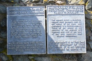
I was delighted to be invited to Wales by my friend and co-editor Professor George Nash to participate in the Gestart Project by creating a work of art in relationship with the Barclodiad y Gawres monument. The goal was to propose a new image of the Welsh Neolithic monument, as well as to enhance the archaeological imagination with the experientiality resulted from the artistic intervention.
I believe that art can function as a revelator for the archaeological imagination; this is why I use the art ingredient in the archaeological experiments, under the form of land-art or installations, which brings new information to complement the scientific one. As an art-chaeologist I combine the scientific approach with the metaphorical one produced by art (Gheorghiu 2009).
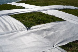
For Barclodiad y Gawres I proposed one land-art installation to visualize, in a minimalistic way, the “invisible” traits of the funerary monument, i.e. its rituality or its relationship with the landscape. Thus, the land-art was conceived as a line which made visible these unseen cultural traits.
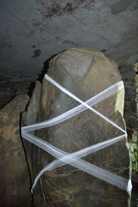
An additional important attribute of the monument that should have been revealed was the art hidden inside the funerary chamber, under the form of incised angular lines and chevrons.
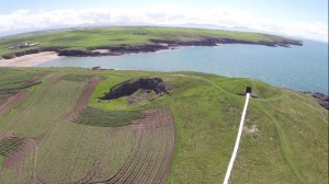
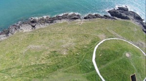
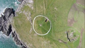
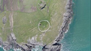
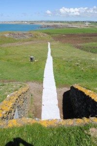
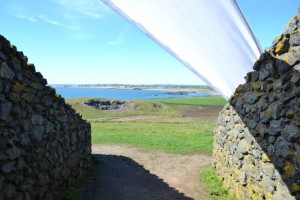
Bearing in mind the monument was placed in a ritual landscape (Nash 2013), I tried to reveal this idea through two artistic and ritual actions. The first art experiment was to separate the shape of the monument from its surroundings, setting apart its round shape from the chaotic forms of the landscape; therefore, viewed from above, the monument was made visible under the shape of a white thin circle, while viewed from ground level, as a horizontal white line, similar to the one produced by the white quartz at Avebury. George experienced the perception of this land art creation from the other side of the gulf near the monument.
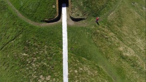
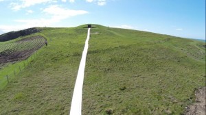
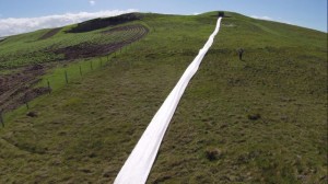
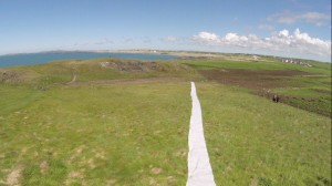
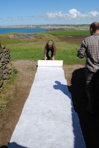
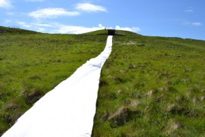
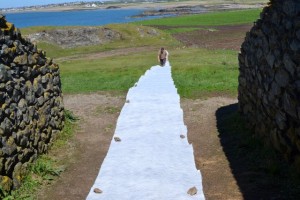
A second experiment and land-art was created to evoke a (hypothetical) ritual road that would have linked the entrance of the monument to the most important visual attractor in the area, Holy Head. The road was materialized as a 100 m long white line, which linked the monument to the valley, and George experienced the rite of approaching the monument on this abrupt road.
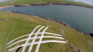
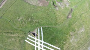
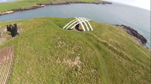
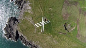
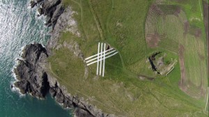
The third land-art was intended to reveal the hidden art inside the monument, by designing a linear pattern resulted from the intersection of parallel white lines across the monument, in order to evoke and made visible to the world the lozenges and the other linear patterns found within the funerary chamber.
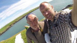
All the grandeur of the land-art and of the monument was captured with the help of a video camera positioned on a drone piloted by Andrew Beardsley. I was helped to position the land-art on the ground by George Nash, Bill Swan, and Andrew Beardsley, while the photos and video films were done by Andrew Beardsley, to whom my thanks go. Moreover, it seems that the Neolithic gods were smiling upon us on the 21st May, as we enjoyed a sunny day with clear skies that one usually only sees on the Mediterranean coast.
The art-chaeological experiment from Barclodiad y Gawres, (i.e. the three land-art works and their theoretical support) constitutes the subject of several scientific and art papers to be published in the next few months, about the uses of art for enhancing the archaeological imagination. Images of my work in Barclodiad y Gawres can also be seen on Gestart Project site (www.gestartproject.com).
For a better understanding of the uses of the art-chaeolgical concept to reveal prehistoric and ancient monuments I invite the interested reader to see my previous work in the Leonardo Electronic Almanac (Gheorghiu 2013), World Art (Gheorghiu 2012), Artchaeology (Gheorghiu 2009), Time Maps (http://timemaps.net/timemap/velho_da_zimbreira/), and the images posted on Panoramio.

DCIM101GOPRO
Dragos-Gheorghiu-and-Andrew-Beardsley_21st-May-2014_Barclodiad-Y-Gawres_photo-Andy-Beardsley

Dragos, Andy and George_21st may 2014_Barclodiad Y Gawres_photo Bill Swann_m
Dragos-Andy-and-George_21st-may-2014_Barclodiad-Y-Gawres_photo-Bill-Swann

entrance in the Neolithic tomb_Barclodiad Y Gawres_photo DG_m
Entrance-in-the-Neolithic-tomb_Barclodiad-Y-Gawres_photo-DG

DCIM101GOPRO
Landart-by-Dragos-Gheorghiu_-21st-May-2014-at-ByG_GestART-Project_photo-Andy-Beardsley

DCIM101GOPRO
Landart-by-Dragos-Gheorghiu_-21st-May-2014-at-ByG_GestART-Project_photo-Andy-Beardsley

DCIM101GOPRO
Landart-by-Dragos-Gheorghiu_-21st-May-2014-at-ByG_GestART-Project_photo-Andy-Beardsley

DCIM101GOPRO
Dragos-Gheorghiu-and-Andrew-Beardsley_21st-May-2014_Barclodiad-Y-Gawres_photo-Andy-Beardsley

DCIM101GOPRO
Landart-by-Dragos-Gheorghiu_-21st-May-2014-at-ByG_GestART-Project_photo-Andy-Beardsley

DCIM101GOPRO
Landart-by-Dragos-Gheorghiu_-21st-May-2014-at-ByG_GestART-Project_photo-Andy-Beardsley

DCIM101GOPRO
Landart-by-Dragos-Gheorghiu_-21st-May-2014-at-ByG_GestART-Project_photo-Andy-Beardsley

DCIM101GOPRO
Landart-by-Dragos-Gheorghiu_-21st-May-2014-at-ByG_GestART-Project_photo-Andy-Beardsley

DCIM101GOPRO
Landart-by-Dragos-Gheorghiu_-21st-May-2014-at-ByG_GestART-Project_photo-Andy-Beardsley

DCIM101GOPRO
Landart-by-Dragos-Gheorghiu_-21st-May-2014-at-ByG_GestART-Project_photo-Andy-Beardsley

DCIM101GOPRO
Landart-by-Dragos-Gheorghiu_-21st-May-2014-at-ByG_GestART-Project_photo-Andy-Beardsley

DCIM101GOPRO
Landart-by-Dragos-Gheorghiu_-21st-May-2014-at-ByG_GestART-Project_photo-Andy-Beardsley

DCIM101GOPRO
Landart-by-Dragos-Gheorghiu_-21st-May-2014-at-ByG_GestART-Project_photo-Andy-Beardsley

Landart by Dragos Gheorghiu_21st May 2014 at ByG_GestART_photo George Nash_1_tw
Landart-by-Dragos-Gheorghiu_21st-May-2014-at-ByG_GestART_photo-George-Nash

Landart by Dragos Gheorghiu_21st May 2014 at ByG_GestART Project_photo George Nash_1_m
Landart-by-Dragos-Gheorghiu_21st-May-2014-at-ByG_GestART-Project_photo-George-Nash

landart by Dragos Gheorghiu_Barclodiad Y Gawres_GestART Project_21 May 2014_photo DG_1_m
Landart-by-Dragos-Gheorghiu_Barclodiad-Y-Gawres_GestART-Project_21-May-2014_photo-DG

landart by Dragos Gheorghiu_Barclodiad Y Gawres_GestART Project_21 May 2014_photo DG_2_m
Landart-by-Dragos-Gheorghiu_Barclodiad-Y-Gawres_GestART-Project_21-May-2014_photo-DG

landart by Dragos Gheorghiu_Barclodiad Y Gawres_GestART Project_21 May 2014_photo DG_3_m
Landart-by-Dragos-Gheorghiu_Barclodiad-Y-Gawres_GestART-Project_21-May-2014_photo-DG

Revealing the incised pattern on a stone-Installation by Dragos Gheorghiu_Gest Art Project_21 May 2010_photp DG_m
Revealing-the-incised-pattern-on-a-stone-Installation-by-Dragos-Gheorghiu_Gest-Art-Project_21-May-2010_photo-DG

Revealing the patterns inside the funerary chamber_land art by Dragos Gheprghiu_Barclodiad y Gawres_GestART Project_21 May 2014_photo DG_tw
Revealing-the-patterns-inside-the-funerary-chamber_land-art-by-Dragos-Gheorghiu_Barclodiad-y-Gawres_GestART-Project_21-May-2014_photo-DG

Bibliography
Dragos Gheorghiu, 2013, Not here Not There, Leonardo Electronic Almanac 19 (1), pp. 54-60.
Dragos Gheorghiu, 2012, eARTh Vision (Art-chaeology and digital mapping), World Art,
2:2, 211-217.
Gheorghiu, D., 2009, Artchaeology. A sensorial approach to the past, Bucharest, Unarte.
George Nash, 2013, Aspect, Architecture and Art: The Passage Grave tradition of Northwest Britain, Time and Mind 6 (2), pp.199-210.

Photos by Dragos Gheorghiu and George Nash. Aerial photos by Andy Beardsley.

Time Maps on the V-must Network of Virtual-Museums

http://www.v-must.net/virtual-museums/vm/timemaps-2013

Participation at the International Conference Mapping Culture: Communities, Sites and Stories

On 28-30 May2014 Professor Dragoş Gheorghiu and Dr.Davide Delfino presented a paper on mapping invisible communities (the Time Maps Project) during the International Conference Mapping Culture organized by the University of Coimbra.
http://www.ces.uc.pt/eventos/mappingculture/
Mapping

The Gestart Project

http://pacadnetwork.com/gestart/